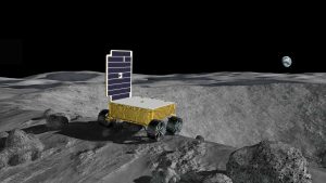
A small autonomous rover is exploring the surface of the moon. It arrived aboard a lander, which set down near the known location of a pit. One of the rover’s directives is to gather imagery of this pit and transmit that imagery to the lander, which will then forward the collected data on to Earth. The rover was deployed from the lander and has since been executing various mission objectives, the most recent of which was to autonomously travel to a waypoint set for it by human operators on Earth. This waypoint is in close proximity to the pit, and is outside of the communication range of the lander, meaning that the rover must operate with complete autonomy during its trek to this waypoint.
The pit’s location is defined by a map of the area around the landing site that was generated before the mission launched. Prior to the start of the rover’s mission, the lander provided the rover with exact coordinates of the lander’s location on this map. The rover localizes itself and the pit in relation to these coordinates for the duration of its mission.
Upon arrival at the waypoint, the rover software activates the Pit Navigator routine, which employs specialized behavior designed for successful navigation in the vicinity of the pit. First, the rover trains its cameras in the direction of the pit’s expected location. It collects images of its surroundings and attempts to identify the pit from those images. The rover calculates an estimate of the location and dimensions of the pit, which is incorporated into the rover’s map of its surroundings.

As soon as the rover has modeled the pit in its global map, it autonomously selects a new waypoint at the edge of the pit. A local planning algorithm generates a route to this waypoint consisting of multiple small movement steps. The algorithm avoids any obstacles detected in the rover’s vicinity and prevents the rover from moving too close to the pit edge, then selects the most optimal route to the destination position with these constraints applied.
The rover begins to execute the planned route to the destination waypoint. After each movement step, the rover uses its navigation cameras to collect information about the area in front of it and uses its pit imagery camera to capture new images of the pit. These pit images are used to update and refine the rover’s model of the pit. Both the pit images and the navigation images are used to update the planned route in order to account for unforeseen obstacles and dangers.
When the rover reaches its destination, it uses the pan and tilt actuators on its pit imagery camera to align the camera such that the camera’s field of view is trained on the pit wall opposite the rover’s location. The camera pans from side to side, taking images at a range of angles in order to capture an arc of the pit wall. Each of these images is incorporated into the rover’s model of the pit. Once sufficient images have been captured, the rover uses its model of the pit to select a new waypoint at a different point on the pit’s circumference, and plots a new path to reach that waypoint. This path takes the rover away from the pit edge before moving around the perimeter of the pit, to ensure that the rover will not fall into the pit while navigating to the next waypoint.
The rover will continue to select waypoints around the edge of the pit and take images at each point until the sun sets and the rover runs out of battery power, with the goal of collecting data on as much of the pit’s wall area as possible. At all times during its mission, the rover is measuring how much data it has collected. In order to ensure that as much of this data as possible is transmit- ted safely to Earth, the rover will leave the vicinity of the pit at regular intervals in order to return to within the communication range of the lander and deposit all collected data to the lander. When the rover leaves the vicinity of the pit, the Pit Navigator routine ends and control is returned to the standard moon operation subsystems. The data transmitted to the lander includes rover telemetry and navigation images in addition to the pit imagery collected at each of the waypoints. Once data is stored on the lander, the rover will return to the pit once again to collect more imagery for as long as it has sufficient power to continue operating.