Jamie is the Team coordinator at the Yosemite Search and Rescue (YOSAR)[1] team. His team is mainly responsible for conducting SAR activities in the Touloumne Meadows region. He is proud that his team is one of the most well-oiled SAR machines in the world. But that comes at a cost. His team employs only well-trained individuals with strong alpine skills and also makes use of helicopters to search in large areas.
YOSAR team conducts rescue operations on a “pay by mission” basis and the rescue operations involve thorough searches in the meadows, forests and mountains. The operations are expensive and each rescuer in the team has to be paid $ 23-34 per hour. Given the large area to traverse, most operations require at least a couple of helicopters, if not more. Moreover, finding good rescuers is a challenge in itself due to the stringent requirements posed by the task. Browsing over the internet, he stumbles on a video showcasing the “Rescue Rangers” drone with the ability to search for human beings in relatively un-occluded environments. He immediately sees the value in using it for his missions as a cheaper option with much faster response and decides to own it.
When the package arrives, he is excited to open it and finds the set up pretty simple – assembling the parts of the drone – not any more difficult than assembling furniture these days. He installs a mandatory software on his laptop to help give the drone inputs and goes through a few tutorials provided to help operate the system. It takes him less than a couple hours to set everything up. Happy with his new gizmo, he wraps up the day unaware of the situation that awaits him the next day.
At 6 in the morning, while nicely tucked in his bed, he receives an emergency SAR SOS from the Yosemite Emergency Communications Center. Two hikers had wandered off the trail and had gone missing for the past two hours. The agency managed to get their approximate location two hours ago and there was also a mention of one of them being severely bruised as well. Jamie immediately sends an alarm to gather the team and prepare for rescue. While preparing for his mission, he glances at the drone he had set up the previous night and wonders if this is the right opportunity to put the drone to test , since he also recollects that the area around the location provided is not covered with trees. “Half an hour for assembling the team should be enough to test the drone”, he thinks to himself.
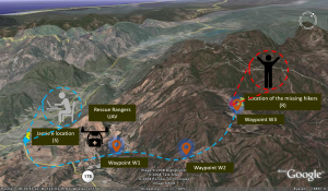
He fires up his laptop and switches the drone’s power ON in the lawn outside. On the software suite, he is able to see Google maps of the nearby area with GPS coordinates. He selects the option “Search and map” and feeds in the three GPS coordinates (Waypoints W1, W2 and W3[a] in Figure below) around the provided location where he reckons the hikers might be. The drone takes off (from location S in the Figure below) and he resumes his preparation for the operation. 20 minutes later, his team is assembled with all the equipment and he briefs them on the mission and they are all set to leave. Just as they can start, the drone comes back to the base. Jamie connects the drone to the laptop with a USB cable and data are transferred by the software in 5 minutes.

Figure: Illustration of how Rescue Rangers aerial system works (waypoints, terrain and visible distances for illustrative purpose only) [Background image sourced from:[2]]
In another 3 minutes, the software pops up with some relevant pictures found and their locations on the map. Jamie is awestruck with the capability. He could easily see the two hikers in one of the pictures. He immediately communicates the location to his team. Figuring that the team still might take some time to reach the location, he attaches a first aid package to the drone and switches ON its power. He selects the option “Drop package” on the software and specifies the chosen location. The drone takes off and comes back in 10 minutes. After another 30 minutes, the team brings the two hikers via a helicopter to the base to treat and tells Jamie that the victim had already gotten first aid before the team could find them. ! MISSION ACCOMPLISHED !
[1] Use case has been designed after reading cases “Yosemite National Park, California”. Refer to links: https://www.nps.gov/yose/blogs/psarblog.htm, https://www.nps.gov/yose/getinvolved/sar_jobs.htm, https://www.nps.gov/yose/blogs/Three-Distressed-Hikers-Rescued-Tuolumne-Meadows-Area.htm, http://www.climbing.com/news/10-things-you-didnt-know-about-yosar/